Looking for a deep dive into Osaka’s canal history? This guide covers the key waterways that shaped the city — from the Dotonbori Canal’s 17th-century origins to Nakanoshima’s Edo-period trading island — and the best spots along each one to walk, cruise, and understand how water built one of Japan’s great cities.
MICHI’s Pick — Selected by our Osaka-based team, based on places we’ve visited and on research using Tabelog and Google Maps ratings. In Japan, a Tabelog score of 3.4+ is genuinely high — Japanese reviewers are famously strict, and most locals consider anything above 3.4 a place worth a detour. We feature venues meeting at least one of: Tabelog 3.4+, Google Maps 4.3+, or 100+ reviews — the kind of spots locals quietly trust.
Tabelog and Google Maps scores are accurate as of the time of writing.
Osaka’s relationship with water is not incidental — it is foundational. Stretching along Osaka Bay and crisscrossed by rivers and canals, Osaka is known as the “city of water,” and its abundant waterways spurred its development and laid the groundwork for a thriving community. The canals were not decorative. They were the roads. Goods moved by boat, markets clustered at riverbanks, and entire neighbourhoods grew up around the logic of water access. To understand Osaka’s neighbourhoods today — why Dotonbori is an entertainment district, why Nakanoshima became a civic and financial hub, why the city’s street grid bends the way it does — you need to understand the waterways first. This is that story, told canal by canal, with practical guidance on where to go and what to look for. For more on what to eat and drink along the way, see the best food in Osaka.
1. The Dotonbori Canal (道頓堀川) — Where It All Began
📍 Dotonbori Canal, Chuo-ku, Osaka (runs east–west through Namba)
🕐 Tonbori River Walk: open 24 hours; Tombori River Cruise: approx. 11:00–21:00 (as of May 2026)
💰 Tombori River Cruise: ¥1,000 per adult (boat only)
🚃 Namba Station (3 min walk)
🗣 English menu: N/A (outdoor attraction; cruise commentary available in Japanese and English)
⭐ Rating: Google 4.4 (8,000+ reviews for Dotonbori area) (as of writing)
🗺 Open in Google Maps
📋 Tabelog
What to order: Takoyaki from any stall on the south bank (¥500–¥700 for 6 pieces)
Dotonbori traces its history back to 1612, when the administrator of local canals, Nariyasu Doton, began construction of the canal on the southern edge of Osaka. Construction was interrupted — Nariyasu Doton died during the Siege of Osaka in summer 1615, but his collaborators continued the work and the canal was completed by September of that year. The new lord of Osaka Castle, Matsudaira Tadaaki, named the canal and avenue beside it Dotonbori — “bori” from “hori,” meaning “canal” — even though Nariyasu Doton had been on the losing side during the siege.
The character of Dotonbori became defined in 1621 when the Tokugawa Shogunate designated it as the entertainment district of Osaka. Yasui Kuhe is credited with luring playhouses and performance tents to the district, and by 1662 the avenue boasted six Kabuki theatres and five Bunraku theatres. The canal was the artery that fed all of it — audiences arrived by boat, and until the middle of the Meiji period, when boat transport was popular, many people would go to see plays on houseboats and tea boats, and they could enter the theaters directly from the river.
With the rise of motorised transport after World War II, much of this traffic shifted to the road system, and Osaka’s waterways lost their place at the heart of civic life. To reverse this trend, the city launched a campaign in 2001 to revive the pleasures of waterfront life for visitors and residents alike. Further development of the land bordering the canal began in 2001, and the 170 metres between Tazaemonbashi and Ebisubashi was opened to the public in 2004.
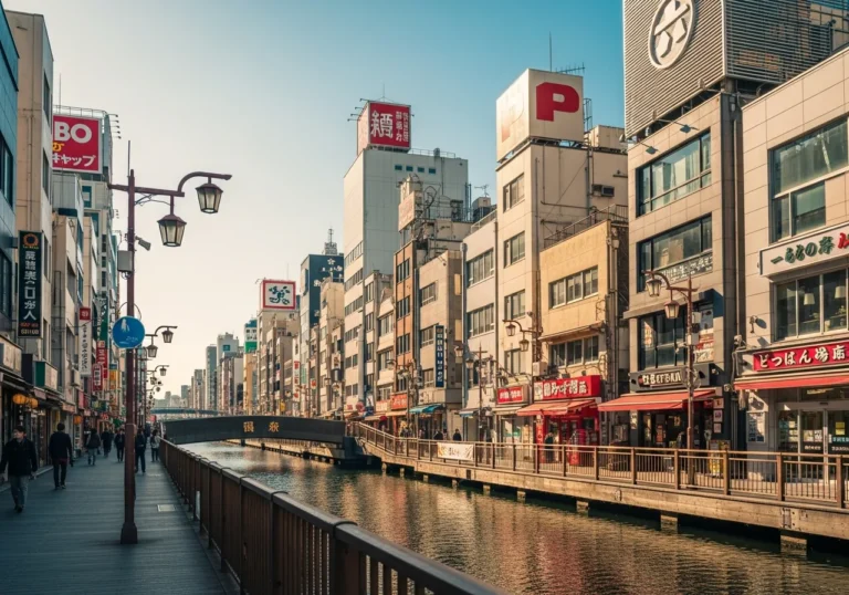
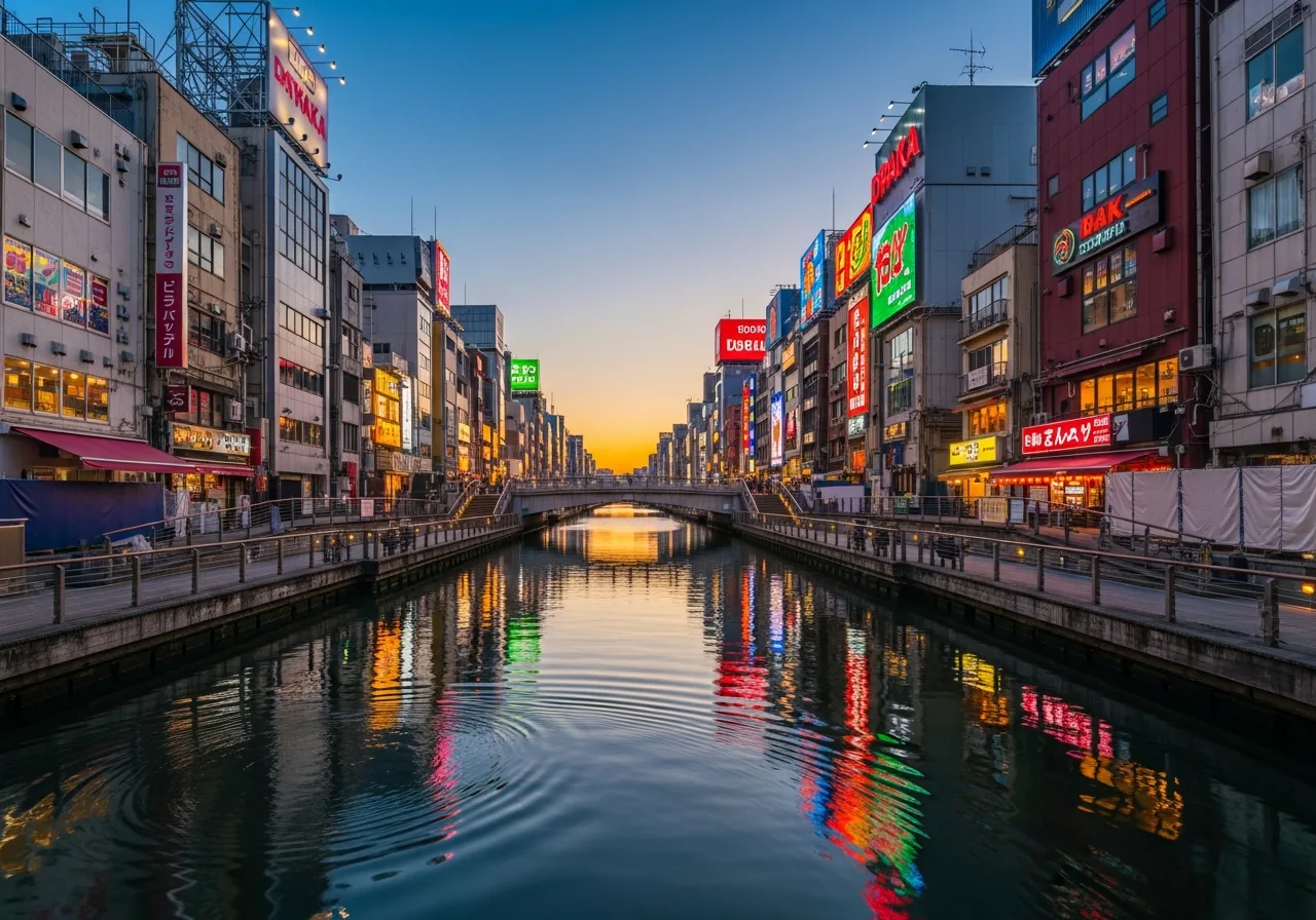
Today the Tonbori River Walk promenade runs along both banks. The Tombori River Cruise, launched in 2005, provides an activity for water lovers and has come to symbolise the revival of the canal. The 20-minute boat ride passes under nine bridges and pauses near the Glico sign — Ebisubashi Bridge was rebuilt in 2007 with a circular plaza at the centre to accommodate the huge volume of visitors, and in a nod to Osaka’s foodways, the railings are shaped like okonomiyaki spatulas.
2. Nakanoshima (中之島) — The Island That Ran the Economy
📍 Nakanoshima, Kita-ku, Osaka (island between the Dojima and Tosabori Rivers)
🕐 Nakanoshima Park: open 24 hours; Nakanoshima Museum of Art: 10:00–17:00, closed Mon (as of May 2026)
💰 Free to walk; museum entry ¥1,200–¥2,000 depending on exhibition
🚃 Yodoyabashi Station (3 min walk) or Nakanoshima Station (Keihan Nakanoshima Line, 2 min walk)
⭐ Rating: Google 4.3 (Nakanoshima Park, 3,000+ reviews) (as of writing)
🗺 Open in Google Maps
📋 Tabelog
What to order: Coffee at any of the riverside cafes on the park’s eastern tip (¥500–¥700)
On a map, Nakanoshima is a long, narrow island stretching approximately 3km east to west and covering an area of approximately 50 hectares, sandwiched between the Dojima River and the Tosabori River. Its position — surrounded by water on all sides — made it the logical centre of Osaka’s commercial life for centuries.
During the Edo period, Nakanoshima was a commercial and logistics centre with many feudal domain storehouses lined up there due to its convenient water transport, and after the Meiji Restoration, it became the site of government offices, schools, and cultural facilities, becoming a hub of the economy and culture. The domain warehouses were where rice from across Japan was stored, weighed, and traded. The world’s first futures trading also took place at the Dojima Rice Exchange — a direct consequence of the waterway infrastructure that made bulk commodity movement possible.
Modern architecture, bridges, and other structures incorporated new designs, and the areas of Nakanoshima, Kitahama, and Semba, where many of these were built, formed the dignified urban landscape of modern Osaka. Today the island holds the Osaka City Central Public Hall (1918), the Osaka Prefectural Nakanoshima Library, and the Nakanoshima Museum of Art (opened 2022). Walk the eastern tip at dusk and you get one of the city’s best views: the Okawa River splitting around the island’s prow, skyscrapers behind, and the old stone bridges lit up in amber.
3. The Higashi-Yokobori River (東横堀川) — Osaka’s Oldest Canal
📍 Higashi-Yokobori River, Chuo-ku, Osaka (runs north–south along the western edge of Osaka Castle)
🕐 Accessible 24 hours; Beta Honmachi Bridge events vary (as of May 2026)
💰 Free to walk
🚃 Honmachi Station (3 min walk)
🗺 Open in Google Maps
📋 Tabelog
What to order: Nothing — this is a walking stretch. Grab a convenience store coffee and go.
The Higashi-Yokobori River is Osaka’s oldest canal, dug some 400 years ago. The Higashi-Yokobori canal was the first planned canal dug by Hideyoshi, in 1585 or 1594, as a moat of Osaka Castle. That origin matters: this waterway was not built for commerce first — it was built for defence. The castle’s western flank was protected by water, and the canal’s north–south alignment defined the boundary between the castle precinct and the merchant city growing up to the west.
In modern times, with the development of railways and automobiles and the postwar economic recovery, many of these canals were filled in. The Higashi-Yokobori survived, but for decades it was effectively invisible — hemmed in by elevated expressways and buildings that turned their backs to the water. Osaka saw its waterways more as a liability than an asset. They were pushed out of sight whenever possible. Even though Osaka promoted itself as a Water City, buildings were actually built with their backs facing the water during the 20th century. Waterways were either filled in and transformed into crowded motorways or hidden below elevated highways.
The revival is slow but real. The Beta Honmachi Bridge project — a pop-up event space on the river — has been running seasonal programming since 2023, bringing food stalls, live music, and design markets to a stretch of water that most Osakans had forgotten existed. It is the most honest illustration of what the city is trying to reclaim.
4. The Dojima Rice Exchange Area (堂島) — Where Futures Were Invented
📍 Dojima, Kita-ku, Osaka (along the Dojima River, north of Nakanoshima)
🕐 Accessible 24 hours; surrounding bars and restaurants typically open from 17:00 (as of May 2026)
💰 Free to walk; dinner in the area ¥3,000–¥8,000 per person
🚃 Watanabebashi Station (Keihan Nakanoshima Line, 2 min walk) or Fukushima Station (JR, 8 min walk)
🗺 Open in Google Maps
📋 Tabelog
What to order: Dinner at any of the izakayas on Dojima’s backstreets (¥3,000–¥5,000 with drinks)
Dojima sits on the north bank of the Dojima River, directly above Nakanoshima. The river gave it everything: access to the domain warehouses on the island below, direct water routes to Osaka Bay, and the ability to move rice in bulk quantities that no road system of the era could match. Regional lords would exchange rice collected through their own land taxation activities and stored at their riverside warehouses in Osaka for money, gauging when rates were most favourable. The world’s first futures trading took place at the Dojima Rice Exchange.
Osaka also became a centre for Genroku culture that flourished from the second half of the seventeenth century to the early eighteenth century. The increased wealth of townspeople during the Edo period allowed many residents to devote time to scholarship and the appreciation of art, literature, and performances of kabuki and puppet theatre. The money that made that culture possible flowed through Dojima’s rice markets. Today the area is a dense cluster of bars, restaurants, and office buildings — the financial district energy has never really left, it just changed form. The riverside walk along the Dojima River at night, with Nakanoshima’s lit-up buildings reflected in the water, is one of the city’s underrated views.
5. The Tombori River Cruise (とんぼりリバークルーズ) — The Canal from Water Level
📍 7-13 Souemoncho, Chuo-ku, Osaka 542-0084 (boarding pier on the north bank of the Dotonbori Canal)
🕐 Approx. 11:00–21:00 daily (last departure varies by season) (as of May 2026)
💰 ¥1,000 per adult / ¥500 per child
🚃 Namba Station (5 min walk)
🗣 English menu: Commentary available in Japanese; some guides speak English
⭐ Rating: Google 4.2 (1,200+ reviews) (as of writing)
🗺 Open in Google Maps
📋 Tabelog
🌐 Official site
What to order: Book the evening departure — the neon reflections on the water after dark are the whole point.
The Tombori River Cruise is a 20-minute sightseeing boat ride that goes from east to west on the Dotonbori River. You can view the flashy store signs of Dotonbori as well as Minatomachi River Place from the comfort of a boat, with the “Osaka Guide Crew” on hand to explain the history and culture of the area. The boat passes under nine bridges — the guide introduces each one, including Ebisu Bridge, which is rounded to resemble okonomiyaki, with railings and steps decorated with spatula motifs.
The Tombori River Cruise is one of the most relaxing ways to explore Osaka. Instead of weaving through the busy streets of Dotonbori, you slip onto the water and see the city from a completely different angle. It is a 20-minute ride, not a deep historical lecture — but the perspective shift is genuine. The canal that Nariyasu Doton started digging in 1612 looks very different from water level than it does from the Ebisubashi selfie scrum above.
6. The Aqua-Liner Cruise (アクアライナー) — Nakanoshima and Osaka Castle by River
📍 Osakajo Pier, 1-1 Osakajo, Chuo-ku, Osaka (near Osaka Castle Park)
🕐 Approx. 10:00–17:00 (6–7 departures per day, roughly hourly); limited service Jan–Feb (as of May 2026)
💰 ¥1,800 per adult / ¥900 per child (round trip)
🚃 Osakajokoen Station (JR, 5 min walk)
🗣 English menu: Audio guide available in multiple languages
⭐ Rating: Google 4.3 (900+ reviews) (as of writing)
🗺 Open in Google Maps
📋 Tabelog
What to order: Take the full round-trip loop — the Nakanoshima stretch is the highlight.
The Osaka Suijo Bus company operates a variety of water bus tours, but the most popular is the Aqua-Liner cruise, which runs regular round-trip cruises on the Okawa River on a route that takes in the greenery of Osaka Castle Park, Nakanoshima island, Sakuranomiya Park, and some of Osaka’s most iconic buildings and bridges. The Aqua-Liner is a specially designed cruise boat with a glass roof that gives unimpeded views of Osaka’s cityscape, and its roof can also be lowered by 30cm when passing under the lowest bridges on the tour route.
Where the Tombori River Cruise is about neon and entertainment history, the Aqua-Liner is about civic and commercial history — the Okawa River was the main artery connecting Osaka to Kyoto, and the view of Nakanoshima from the water is the closest you can get to understanding how the city looked to a merchant arriving by boat in the Edo period. Surrounded by the Tosabori and Dojima rivers, Nakanoshima has been Osaka’s core since the Edo period (1603–1868).
7. The Tonbori River Walk (とんぼりリバーウォーク) — The Promenade That Faced the Water
📍 Tonbori River Walk, Chuo-ku, Osaka (along both banks of the Dotonbori Canal, from Ebisubashi to Tazaemonbashi)
🕐 Open 24 hours (as of May 2026)
💰 Free
🚃 Namba Station (3 min walk)
⭐ Rating: Google 4.1 (500+ reviews) (as of writing)
🗺 Open in Google Maps
📋 Tabelog
What to order: Nothing — walk it, then eat on the street above.
The Tonbori River Walk is the physical result of Osaka’s decision to stop treating its canals as infrastructure to be hidden. Prior to its development, the streets parallel to the canal — Dotonbori Street on the south bank and Soemoncho Street on the north bank — were the focus of activity, and very few storefronts faced the canal itself. The promenade changed that orientation, at least partially. When water transport fell into disuse, the Dotonbori River became the backside of the city, but the Tonbori River Walk was completed on both sides of the river from Ebisubashi to Tazaemonbashi, and restaurants with terrace seating began to appear on the promenade. Pleasure boats can now depart from the pier, and the area is now bustling with people enjoying a stroll along the waterfront.
Walk it at night. The neon from the signs above reflects in the water below, and the low bridges compress the view into something almost theatrical. During summer, the canal is lined with 1,300 paper lanterns. It is the most accessible way to understand what Dotonbori looked like when it was a working waterway — and to see what the city is slowly trying to become again. To plan the rest of your time in the area, explore more of Osaka with our full neighbourhood guide.
8. The Water Corridor (水の回廊) — The Full Loop
📍 The “water corridor” loop: Tosabori River → Higashi-Yokobori River → Dotonbori River → Kizu River, encircling central Osaka
🕐 Accessible 24 hours; Osaka River Loop boat tour operates seasonally (as of May 2026)
💰 Free to walk; Osaka River Loop boat tour approx. ¥1,500–¥2,000 per adult
🚃 Multiple stations along the loop; Honmachi Station is a good starting point
🗺 Open in Google Maps
📋 Tabelog
What to order: Walk the full loop (about 6km) on a clear morning before the crowds arrive.
In modern times, with the development of railways and automobiles and the postwar economic recovery, many of Osaka’s canals were filled in. Nevertheless, modern Osaka is known as the “Water Corridor,” with the Tosabori River, Higashi-Yokobori River, Dotonbori River, and Kizu River surrounding the city in a square shape. This U-shaped loop of waterways — roughly 6km if you walk the full perimeter — is the surviving skeleton of what was once a city threaded through with dozens of canals.
The Osaka Prefecture, Osaka City, and the business community jointly proposed the “Water City Osaka Regeneration Plan,” which aimed to revitalise the entire Osaka region by revitalising the U-shaped river consisting of Nakanoshima, Higashi-Yokobori River, Dotonbori River, and Kizu River as a “water corridor.” In 2001, the rules on the use of river spaces were relaxed, allowing commercial activities such as cafes, riverside terraces, and open terraces to be held on the waterfront, and lively waterfront spaces were created one after another.
Walking the full loop takes about two hours at a relaxed pace. Start at Honmachi Bridge on the Higashi-Yokobori, head south to the Dotonbori, west to the Kizu River, north along the bay-facing stretch, and back east along the Tosabori to Nakanoshima. You will pass through four distinct neighbourhood characters — the old castle-moat quiet of the east, the neon chaos of the south, the industrial-turned-residential west, and the civic grandeur of the north — all connected by the same water that connected them four centuries ago. For everything else worth doing in the city, the MICHI Osaka travel guide has you covered.
FAQ
Q: What is the best canal to visit in Osaka?
A: The Dotonbori Canal is the most immediately rewarding — the neon, the bridges, the Glico sign, and the Tombori River Cruise all concentrate here. But if you want history without the crowds, the Higashi-Yokobori River running along the western edge of Osaka Castle is the city’s oldest canal and far less visited.
Q: How many canals are there in Osaka?
A: At its peak in the Edo period, Osaka had dozens of canals threading through the city. Most were filled in during the postwar economic boom to make way for roads and expressways. Today, the main surviving waterways are the Dotonbori Canal, the Higashi-Yokobori River, the Tosabori River, the Dojima River, the Kizu River, and the Okawa River — together forming the “water corridor” that encircles central Osaka.
Q: Do Osaka canal areas have English signage?
A: The Dotonbori area has extensive English signage and multilingual menus at most restaurants. The Tombori River Cruise offers English commentary. Nakanoshima’s museums and public spaces have good English information. The Higashi-Yokobori and Kizu River stretches are quieter and have less English support — bring Google Maps and you will be fine.
Q: What should I eat near Osaka’s canals?
A: Takoyaki (octopus balls, ¥500–¥700 for 6) along the Dotonbori Canal’s south bank is the obvious answer, and it is obvious for good reason. For a proper meal, the izakayas on the backstreets of Dojima — the old rice-trading district north of Nakanoshima — are excellent and far less crowded than Dotonbori. The canal neighbourhoods are also where Osaka’s kuidaore (“eat until you drop”) culture was born, so the standard is high across the board.
Last updated: July 19, 2026 · Corrections: [email protected]