Osaka was once so thoroughly threaded with waterways that the phrase Naniwa Happyaku-ya-bashi — “the 808 Bridges of Naniwa” — entered the Japanese language as a synonym for uncountable abundance, the way a city could be so laced with canals that counting its crossings became a kind of joke. Then, between the 1950s and the 1980s, the city filled in fifteen or more of those canals and drove a 239-kilometre expressway network over many of the ones it kept, converting the infrastructure of a water civilization into asphalt in a single generation. What Osaka lost was not merely scenery: it was the physical logic of a city that had been engineered, from its very foundations in the sixteenth century, to move goods by water — and with it, a way of reading the city that most residents today can no longer perform.
Why we can tell you this — MICHI is edited in Osaka, and the writers of this piece can stand on Nagahori-dori and look down at the Crysta Nagahori underground mall running beneath their feet — the buried ghost of the Nagahori River, whose canal was filled in and whose bridge railings were salvaged as pedestrian decoration. The research draws on the municipal heritage panels of Osaka’s Chuo Ward, the Aqua Metropolis Osaka Consortium’s official historical archive at suito-osaka.jp, the Osaka City official profile, and academic work on Osaka’s urban history. Where the precise chronology of individual canal-filling decisions is unclear — the process was piecemeal, ward by ward, across several decades — we say so rather than inventing a tidy timeline.
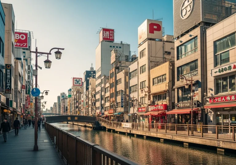
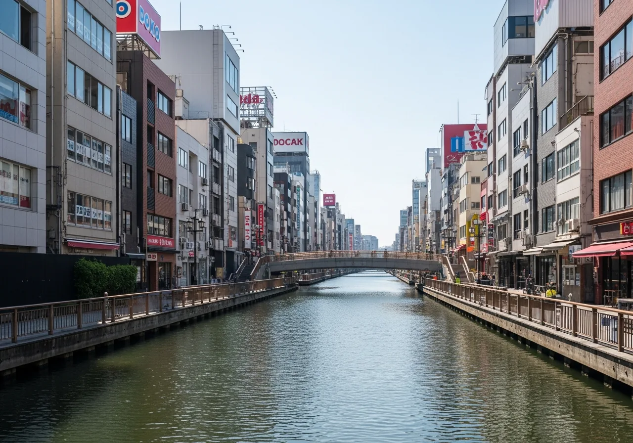
Stand on Ebisubashi on a summer evening and look west along the Dotonbori Canal. The neon signs are blazing, the tour boats are threading under the bridges, and the water catches the light in long orange smears.
It is, by any measure, one of the great urban spectacles of Asia. But look up, and you will see the grey underside of the Hanshin Expressway Loop Route, which has been riding above this stretch of water since 1962, and which tells you, if you know how to read it, that the city once made a choice: concrete over water, speed over depth, the car over the boat.
That choice was not made carelessly, and it was not made all at once. It accumulated across three decades of postwar emergency, economic miracle, and Olympic-era ambition, and it remade a city that had spent four centuries building itself around the premise that water was the fastest, cheapest, and most elegant way to move anything. To understand what Osaka lost, you have to understand what it had — and why it had it in the first place.
Why Did a City of Water Exist Here at All?
Osaka developed around the mouths of the Yodo River and the Yamato River, with many rivers and canals running through the city. That sentence, from the Osaka City official profile, sounds like geography.
It is actually destiny. The site that would become Osaka was a delta: a low, wet, shifting accumulation of silt deposited by two major river systems draining into Osaka Bay.
Building on it required engineering the water, not ignoring it.
Osaka’s history as a crossroads of exchange began with Naniwatsu Port, which was established around the fifth century. As a gateway to the world, Naniwatsu Port served as a departure point for the diplomatic missions of the time, and this thriving trading port welcomed many visitors from abroad.
The name Naniwa itself — the city’s ancient designation, still used in poetry and in the bridge-count phrase — has always carried the meaning of water and passage. The name Naniwa, although written with different characters over the ages, has always been associated with the city’s role as a center of waterborne trade.
The decisive act of hydraulic urbanism, however, came in 1583, when Toyotomi Hideyoshi chose the site for his castle. Hideyoshi originally called for the construction of the city on top of the elevated Uemachi Plateau, but because the western side of the plateau was composed of damp marshland, he was forced to construct a canal to improve drainage.
That canal — the Higashiyokobori River, running north-south along the eastern edge of what would become the Semba merchant district — was not a decorative feature. It was a civil engineering solution to the problem of building a city on a swamp.
When Hideyoshi built the castle town on the west side of Osaka Castle, he also excavated the Nishiyokobori River, running north-south between the Semba district, which was dry land suitable for building, and the marshland further west, to channel the drainage water from the Semba district. The sewer system that flowed into the east-west moat rivers was later called the “Taiko Sewer System” — taiko being an honorific for Hideyoshi — and it was, for its era, a sophisticated piece of urban hygiene. Approximately 20 kilometres of the system is still in use today.
The logic was circular and self-reinforcing: canals drained the land, which made it buildable; building brought merchants, who needed to move goods; moving goods required more canals; more canals required more bridges. The excavation of canals continued into the Edo period, and townspeople who took the initiative in developing them were exempt from land taxes, so they competed with each other to develop them.
The city was, in effect, paying its citizens to build its own infrastructure. The result was a waterway network that grew organically, district by district, merchant by merchant, across the seventeenth century.
Why Were There So Many Bridges — and What Did “808” Actually Mean?
The number 808 was never a census figure. Edo had its 808 districts, Kyoto had its 808 temples, and Osaka, once known as Naniwa, had its 808 bridges — phrases used during the Edo period to symbolize the vibrancy and prosperity of each city. The number was a cultural shorthand, a way of saying “more than you can count, more than any other city, more than seems possible.”
In reality, Osaka had about 200 bridges at the time. By comparison, Edo had approximately 350 bridges — a testament to its status as the shogun’s capital and Japan’s largest city.
But the boast stuck to Osaka rather than Edo, because in Osaka the bridges were not merely functional crossings. They were the joints of a commercial body.
Every bridge connected a warehouse district to a market, a wholesale quarter to a river landing, a theatre to its audience arriving by boat.
Among these bridges, twelve were administered directly by the shogunate government and decorated with giboshi (decorations for bridges), and these were called kogi-bashi (government bridges). The distinction mattered: the government bridges were the city’s official spine, maintained at public expense, while the hundreds of smaller cho-bashi — town bridges — were built and maintained by the merchant communities on either bank.
A bridge was a commercial investment. You built one because you needed to move goods across a canal, and because the foot traffic it generated would bring customers to your warehouses.
By the Meiji era, the count had grown dramatically. Osaka numbered roughly 200 bridges by the Edo period and 1,629 bridges by 1925.
That explosion — from 200 to 1,629 in roughly three centuries — tracks the city’s expansion through industrialization. Each new factory district, each new residential ward pushed into the delta, required its own canal network and its own bridges.
The number peaked, then began its long decline.
Why Did Merchants Build the Canals — and What Did They Build Them For?
The most famous single act of merchant canal-building in Osaka’s history is also the most instructive. Dōtonbori traces its history back to 1612, when the administrator of local canals, Nariyasu Dōton, began construction of the canal on the southern edge of Osaka. The project was commercial in its conception: in 1612, Yasui Dōton invested his personal wealth to excavate a waterway in the Minami district, aiming to expand the existing Umezu River to connect the two branches of the Yokobori River and thereby streamline the transport of goods from Osaka’s ports to surrounding regions for improved commerce, flood control, and transportation.
The canal’s construction was interrupted by war. Yasui Jihē died after an illness and Nariyasu Dōton died during the Siege of Osaka in summer 1615, having fought on the losing side of Toyotomi Hideyori.
Yasui Kuhē and Hirano Tōjirō continued construction and the canal was completed by September 1615. The new lord of Osaka Castle, Matsudaira Tadaaki, named the canal and avenue beside it Dōtonbori.
What happened next reveals the logic of the entire water city. The character of Dōtonbori became defined in 1621 when the Tokugawa Shogunate instituted urban planning and designated Dōtonbori as the entertainment district of Osaka.
Yasui Kuhē is credited with luring playhouses and performance tents to the district, and by 1662, the avenue boasted six Kabuki theatres and five Bunraku theatres, as well as the unique Takeda Karakuri mechanical puppet theatre. A canal dug for cargo became, within a generation, the cultural heart of the city.
The water brought the goods; the goods brought the people; the people needed entertainment; the entertainment needed the water to deliver its audience.
The same pattern repeated itself across the city. The name Semba is written with characters meaning “boat place.” The most widely accepted explanation is that it came from the many wharves in the neighborhood, as canals formed the main transport network at the time.
Semba lies directly to the west of Osaka Castle and developed by utilizing the extensive network of canals for transport. It is bordered by the Higashiyokobori River on the east, the Nishiyokobori River on the west, the Tosabori River on the north, and Nagahori-dori — formerly the Nagahori River — on the south.
The merchant district was, quite literally, an island defined by its canals. Its name told you so.
And around the year 1700, Semba became synonymous with the commercial city of Osaka, and the area flourished as people would proudly boast, “70% of Japan’s wealth is in Osaka, and 80% of Osaka’s wealth is in Imabashi.” That boast was not empty. During the Edo period, Osaka functioned as the nation’s economic clearing house, with feudal domains from across Japan maintaining warehouses on Nakanoshima — the river island between the Dojima and Tosabori rivers — to store and sell their rice tax revenues. During the Edo period, Nakanoshima was a commercial and logistics center with many feudal domain storehouses lined up there due to its convenient water transport, and after the Meiji Restoration, it became the site of government offices, schools, and cultural facilities, becoming a hub of the economy and culture.
Why Did the Water City Reach Its Peak — and Then Begin to Poison Itself?
The Meiji Restoration of 1868 moved the imperial capital to Tokyo and stripped Osaka of its political centrality. But the city’s commercial instincts proved resilient. In the Meiji era, the capital was moved to Tokyo and Osaka’s economy went into decline, but Osaka, which had always been the center of the distribution economy, began to industrialize, with spinning, machinery manufacturing, shipbuilding, and other industries, and it emerged as a center of new industries.
The canals, which had carried rice and cloth, now carried raw cotton, machine parts, and coal. The city expanded outward into the delta, filling in marshland, extending its grid of waterways. From the late Taisho period to the early Showa period, Osaka boasted the largest population in Japan after the second expansion of the city area, and was called “Great Osaka.” It was the leading commercial and industrial city in the Orient, and at the same time, it was a time when culture and the arts flourished and the city was full of energy.
In the closing years of the Taisho period (1912–26), the population of Osaka city exceeded that of Tokyo, and people showed their respect to Osaka by calling the city Dai-Osaka (Great Osaka). This was the high-water mark — in every sense. The city that had built itself on water was now the largest city in Japan, its canals carrying more traffic than ever, its bridges multiplying toward that 1925 peak of 1,629.
But industrialization brought a price. One negative legacy of the urban development of Greater Osaka was that domestic and industrial wastewater flowed into the city’s canals, polluting the rivers.
The city was lined with factory chimneys and the black smoke billowing out meant that the “City of Water” came to be known as the “City of Smoke.” The canals that had defined the city’s identity were becoming its sewers. The water that had made Osaka prosperous was now the medium through which its prosperity was poisoning it.
This is the first of the deeper “whys” that most accounts of Osaka’s canal loss skip over. The decision to fill in the canals after the war was not made in a vacuum of pure automotive enthusiasm.
It was made in a context where the canals were already, by the 1930s and 1940s, associated with pollution, smell, and industrial waste. The water city had been degrading its own infrastructure for decades before the bulldozers arrived.
Why Did the War Accelerate the Destruction — and Why Did the Car Finish the Job?
As is true with Tokyo, the majority of Osaka’s historical monuments were destroyed during the firebombing raids of World War II and the vast majority of the city has been rebuilt since the war. The firebombing of 1945 left central Osaka in ruins.
Central Osaka was reduced to rubble in World War II, but the city made a remarkable recovery in the postwar era. That recovery, however, was shaped by the priorities of the moment: speed, capacity, and the automobile.
The logic of the canal-filling was, in its own terms, impeccable. After World War II, rapid economic development led to the pumping of groundwater, which caused Osaka, which was already low-lying, to sink even further, and seawalls were built to protect against high tides in coastal areas that had suffered repeated flooding.
The city was literally subsiding. The canals, already polluted, were now also a flood risk in a city that was sinking into its own delta.
Filling them in was presented — and genuinely understood — as a public safety measure as much as a modernization project.
Then came the expressway. By the time Japan began building its urban expressway network in the 1960s and 70s, cities like Tokyo and Osaka were already densely developed.
There was no room for the kind of wide, ground-level highways seen in American cities. The solution was elegant in its brutality: the most available space wasn’t land — it was water.
Many of Japan’s urban expressways were built along — and directly above — existing rivers and canals.
The Hanshin Expressway is a 239.3-kilometre network of expressways surrounding Osaka, Kobe, and Kyoto. It opened in 1962.
In 1962, Loop 1 of the Hanshin Expressway was routed above a portion of Dotonbori that turns to the north. The expressway did not fill in the Dotonbori Canal — it simply drove over it, casting it into permanent shadow.
But for the canals that were filled in, the process was more total. Many of the canals have been filled in, but some have been built over with the Hanshin Expressway.
The Aqua Metropolis Osaka historical archive lists the major reclaimed canals: the Tenma Horikawa, the Nagahorikawa, the Takatsuiri Horikawa, the Nanba Shinkawa, the Nishi Yokohorikawa, the Edo Horikawa, the Kyomachi Horikawa, and others — fifteen named waterways that were filled in entirely, their names surviving only in street names and underground shopping malls. As transportation shifted mainly to rail and automobiles, the canals, which were losing their function, were filled in one after another and turned into roads, or covered by expressways, and the area lost its image as a water city.
The Nagahori River is the most instructive case. This was the first bridge to stretch across the Nagahori River, a canal roughly 2,500 metres long and 30–40 metres wide which was excavated in 1625 to connect the Higashi-Yokobori and Kizugawa Rivers.
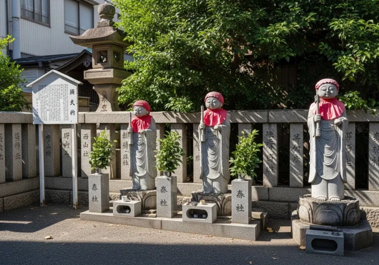
The canal that Shinsai Okada was one of four merchants who had constructed in 1622, calling it Nagahorigawa — the canal that gave Shinsaibashi its name, because Shinsai built a bridge (hashi) across it — was filled in to become Nagahori-dori, the broad east-west boulevard that now carries the Hanshin Expressway overhead and the Nagahori Tsurumi-ryokuchi subway line underground. Although the canal was eventually filled in to become a road, now Nagahori-dori, part of the bridge was saved to decorate the pedestrian walkway that crosses this street, above the Crysta Nagahori underground shopping mall.
The bridge railings, salvaged and repurposed as decoration in a shopping tunnel: a city’s memory compressed into an architectural footnote.
The Nishiyokobori River — the canal Hideyoshi had dug in the sixteenth century to drain the Semba district — became the northbound lanes of the Hanshin Expressway. Semba is bordered by the Higashiyokobori River on the east, the Nishiyokobori River — now where northbound lanes of the Hanshin Expressway run — on the west, the Tosabori River on the north, and Nagahori-dori — formerly the Nagahori River — on the south.
The merchant district that had been defined by its surrounding canals was now defined by its surrounding roads. The water had been replaced by asphalt, and the city that had once been read by its bridges was now read by its interchanges.
The Semba Centre Building: A Monument to the Compromise
The most extraordinary physical artifact of this transformation stands in the Semba district today. Eventually Horikawa and other canals were filled in to make roadways, and as north-south roadways were widened, Osaka acquired its regular grid of arterial streets.
Amid the urbanization and rapid economic growth that followed the Second World War, Semba, near the heart of the city, found itself on the route planned for a main east-west highway. Negotiations to relocate the neighborhood’s dense wholesale district stalled due to high land prices, and the solution that emerged was to integrate a large building into the highway structure and sell space to businesses, thereby avoiding division of the neighborhood and lowering the overall construction costs.
The Semba Centre Building opened in 1970 during Expo Osaka, the Japan World Exposition.
The Semba Centre Building is, in its way, a perfect symbol of what happened to Osaka’s water city. It is a long, low commercial building — a wholesale arcade — with a highway running along its roof.
The canal that once defined the southern boundary of the Semba district has become a road; the road has become a building; the building has become a market. The logic of commerce has survived; the logic of water has been buried beneath it.
Why Did the Bridge Count Keep Falling — and What Does the Number Tell Us?
The bridge count is the most precise instrument we have for measuring what was lost. Osaka numbered roughly 200 bridges by the Edo period and 1,629 bridges by 1925.
As many of the city’s canals were gradually filled in, the number dropped to 872, of which 760 are currently managed by Osaka City. That fall — from 1,629 to 872 — represents not just the loss of bridges but the loss of the waterways those bridges crossed.
Every bridge that disappeared took a canal with it.
The trajectory is worth dwelling on. The city reached its maximum bridge count in 1925, at the height of the Great Osaka period.
The firebombing of 1945 destroyed many bridges but not the canals beneath them. The real decline came in the postwar decades, as the canal-filling program gathered pace.
The Nippon.com history of Osaka as a water city notes that the city’s connection to its waterways was severed not in a single dramatic act but in a long, incremental process of administrative decisions, each individually defensible, collectively transformative.
The 1970 World Exposition accelerated the process. The 1970 Osaka Expo, held in the Senri Hills to the north of the city with the theme of “Progress and Harmony for Mankind,” became a symbol for Japan’s high-growth period.
The first World Exposition to take place in Asia, it attracted a record 64 million visitors. Preparing for 64 million visitors required infrastructure: roads, expressways, subway lines.
In Japan, 1970 marked a decade of unprecedented growth and optimism among large numbers of Japanese, who were convinced the future would only get brighter despite growing problems of environmental pollution and an urban infrastructure struggling to keep up with the waves of people relocating from rural to urban areas. The Expo was both a celebration of progress and a driver of the very infrastructure decisions that were erasing the water city.
There is a painful irony in the fact that the Bureau International des Expositions records that the overall economic effect of Expo 1970 was estimated to be 3.5 trillion yen nationally, and 1.1 trillion yen within the Kansai region alone. The money that flowed from the Expo funded the roads that replaced the canals. Progress paid for its own contradictions.
Why Did the City Turn Its Back on the River — and What Was the Human Cost?
The physical changes had a psychological dimension that is easy to underestimate. Although the concrete revetments provided some flood protection, the inorganic concrete separated the waterfront from the land, and people lost their connection with the river and began to lose interest in the waterfront.
This is the mechanism that urban historians call “severance”: when infrastructure cuts a community off from a natural feature it has historically used, the community does not simply adapt — it forgets. Within a generation, the waterfront becomes invisible, the canal becomes a drain, the bridge becomes a traffic junction.
As Takuji Kobayashi, an engineer and board member of the waterfront advocacy group Mizube NPO, has lamented: “For many people in Osaka today, the bright scene of a flourishing water capital does not exist even in their memories.” That sentence is the sharpest possible summary of what was lost. It was not just the canals. It was the memory of the canals — the cultural knowledge of what it meant to live in a city organized around water.
The buildings turned their backs, literally. Vertical banks are continuous and the area is not hydrophilic, so many buildings face away from the river.
Walk along the Higashiyokobori River today — one of the few major canals that survived — and you will see what this means: buildings that present their service entrances, their loading docks, their blank concrete walls to the water. The river is there, but the city has decided not to look at it.
This is the architectural expression of a cultural decision made in the 1960s and 1970s, and it persists in the built fabric of the city today.
The groundwater pumping that accompanied rapid industrialization made things worse. With the rapid expansion of economic activity and population growth that came with Japan’s high economic growth, domestic and industrial wastewater began to flow into rivers, causing water quality to deteriorate, and people began to lose interest in the waterfront.
The canals smelled. They were dark.
They were associated with industrial waste and urban poverty. Filling them in was not experienced, by most Osakans of the 1960s, as a loss.
It was experienced as improvement.
This is the deepest “why” in the story: the canal-filling was popular. It was not imposed by technocrats against the wishes of a water-loving public.
The public, living with polluted, subsiding, flood-prone canals in a city that was growing faster than its infrastructure could manage, largely welcomed the roads. The loss was not felt until the generation that remembered the water city had passed, and the generation that inherited the roads had no reference point for what had been there before.
Why Did Osaka Try to Reclaim Its Water Identity — and Is It Working?
The turn came gradually, beginning in the 1970s with the first serious water quality improvement programs, and accelerating in the 1990s and 2000s as the city began to understand what it had given up. Starting in the 1930s, many of the waterways that had formed the backbone of Osaka had deteriorated due to poor water quality and the prevalence of land transportation. However, in the 1970s, steps were taken to improve the water quality of the rivers, and in 2001, efforts began to revive the city as “Aqua Metropolis Osaka.”
In 2001, Osaka Prefecture, Osaka City, and the business community jointly proposed the “Water City Osaka Regeneration Plan,” which aimed to revitalize the entire Osaka region by revitalizing the U-shaped river consisting of Nakanoshima, Higashi-Yokobori River, Dotonbori River, and Kizu River as a “water corridor.” Furthermore, in 2001, the rules on the use of river spaces were relaxed, allowing commercial activities such as cafes, riverside terraces, and open terraces to be held on the waterfront, and lively waterfront spaces were created one after another.
The results are visible. The Tombori Riverwalk along the Dotonbori Canal, completed in 2004, restored public access to a waterfront that had been walled off for decades.
Nakanoshima Banks is a 400-metre-long waterfront space on the left bank of the Dojima River, stretching from Dojima Ohashi Bridge to Tamae Bridge. The space was created in conjunction with the restoration work for the construction of the Keihan Nakanoshima Line, and in 2008, the Nakanoshima area was designated a social experiment zone by the Ministry of Land, Infrastructure, Transport and Tourism, creating a framework for private use of the river space.
The Aqua Metropolis Osaka Consortium — a joint initiative of the prefecture, the city, and the business community — has been running river events, boat tours, and waterfront activation programs for two decades. The Consortium has recently launched the “Aqua Metropolis Osaka Building,” which depicts the vision Osaka aims to have as a water metropolis by 2030. The Osaka River Loop, a boat service that circles the surviving water corridor, was piloted as a social experiment in 2025, with the aim of establishing private operators on the route.
But the revival is partial, and the honest assessment requires acknowledging its limits. The filled canals are not coming back.
The Nagahori River is a road. The Nishiyokobori River is a highway.
The Tenma Horikawa, the Edo Horikawa, the Kyomachi Horikawa — fifteen named waterways — are buried under asphalt and concrete. What the Aqua Metropolis program can do is restore the relationship between the city and the water that remains.
It cannot restore the water itself.
Even today, the city retains its water history in many geographical names using the words bashi (bridge) — as in Yodoyabashi, Nipponbashi — and hori (manmade canal) — as in Dotonbori, Karahori. The city’s map is a palimpsest: the names of the canals and bridges survive in the street signs and station names, even when the water and the bridges themselves are gone.
Walking Osaka with this knowledge is a different experience from walking it without it. The city becomes legible in a new way — or rather, in a very old way, the way it was always meant to be read.
Why Should a Discerning Traveler Care About Buried Canals?
The question is fair. Osaka is magnificent without knowing any of this.
The food is extraordinary, the people are warm, the energy of Dotonbori at night is one of the great urban experiences of the world. Why does it matter that the canal beneath the Hanshin Expressway was once the Nishiyokobori River, or that the boulevard you are walking was once a waterway?
It matters because understanding the loss changes what you see. When you stand on Ebisubashi and look at the Dotonbori Canal, you are looking at one of the survivors — a canal that was not filled in, that was restored and activated, that now carries tour boats and reflects neon signs.
Its survival was not inevitable. The canal next to it, and the one next to that, were filled in.
The fact that Dotonbori still exists as water, rather than as a road or a shopping arcade, is the result of a specific set of decisions, and understanding those decisions makes the canal more, not less, remarkable.
When you walk Nagahori-dori and see the Crysta Nagahori underground mall running beneath it, you are walking over a buried river. The mall’s name — Crysta, from “crystal,” evoking water — is not accidental.
The city knows what is under there. After you cross the now-landfilled Nagahori River, Semba gives way to Shinsaibashi.
The parenthetical “now-landfilled” is doing a great deal of work in that sentence. It is the entire history of the water city compressed into two words.
And when you visit Nakanoshima — the river island between the Dojima and Tosabori rivers, now home to the Museum of Oriental Ceramics, the Osaka City Central Public Hall, and the rose garden — you are standing on the commercial heart of Edo-period Japan, the place where the feudal domains stored their rice and where the nation’s wealth was calculated and traded. The island survived because it was an island: the rivers that defined it could not be filled in without destroying the island itself. Its survival is a geographical accident, and it is the most complete surviving piece of the water city.
The deeper significance for the traveler is this: Osaka is a city that made a catastrophic urban planning decision in the mid-twentieth century, recognized it, and has been trying to undo it ever since. That story — of loss, recognition, and partial recovery — is more interesting than the story of a city that simply preserved its heritage.
It is a story about what cities choose to value, and when, and why. It is a story about the relationship between infrastructure and identity, between the physical form of a city and the culture that grows in it.
The water city is not gone. It is buried, partially, under roads and expressways.
But it is also present, in the surviving canals, in the place names, in the bridge railings salvaged into shopping-mall decoration, in the boat tours that now circle the water corridor on summer evenings. After World War II, starting in the 1960s, most of Osaka’s canals were reclaimed to build some 40 miles of criss-crossing highway for the city’s three million residents.
Forty miles of highway, built on the bones of the water city. Walking those forty miles — or rather, walking the streets that replaced the canals — is one of the most instructive things you can do in Osaka.
The city is telling you its history in the only language it has left: the language of roads where rivers used to be.
Frequently Asked Questions
Q: Did Osaka really have 808 bridges?
A: No — the number was figurative, a cultural expression of abundance. The phrase appears in Edo-period literature as a way of indicating impressiveness and the “uncountable.” In reality, Osaka had about 200 bridges at the time. The city later grew to 1,629 bridges by 1925, before the canal-filling program reduced the count to its current level.
Q: Which canals can I still see in Osaka today?
A: The main surviving canals are the Dotonbori River (the most famous), the Higashiyokobori River, the Tosabori River, the Dojima River, and the Okawa (the main channel of the Yodo River). Nakanoshima island, between the Dojima and Tosabori rivers, offers the most complete surviving experience of the water city’s geography.
Q: Can I take a boat tour of Osaka’s waterways?
A: Yes. Osaka Prefecture is working to create a lively waterfront and revitalize water transportation by utilizing the water corridor that surrounds the center of Osaka.
The Osaka River Loop operates as a social experiment to create a route that circles the water corridor by boat. Multiple private operators also run tours on the Dotonbori Canal and the Okawa River.
Q: Where can I learn more about Osaka’s water city history?
A: The Aqua Metropolis Osaka website (suito-osaka.jp) has an excellent English-language historical archive. The Osaka Museum of History, near Osaka Castle, covers the city’s development from ancient times. The Chuo Ward heritage panels — accessible at osaka-chushin.jp — provide detailed histories of individual bridges and canals in the Semba and Dotonbori areas.
Q: Is the Hanshin Expressway being removed from above the canals?
A: There are ongoing discussions about the future of the expressway network as it ages, but no confirmed plans to remove the sections above the surviving canals as of August 2026. The city’s Aqua Metropolis 2030 vision focuses on activating the waterfront spaces that exist rather than removing the expressway infrastructure above them.
Nakanoshima & Osaka’s Water Corridor — Visitor Information
Address: Nakanoshima, Kita-ku, Osaka 530-0005 / 大阪府大阪市北区中之島
Nearest station: Nakanoshima Station (Keihan Nakanoshima Line) — 1 min walk; Yodoyabashi Station (Osaka Metro Midosuji Line / Keihan Main Line) — 5 min walk
Hours: Outdoor riverside areas accessible at all times; Nakanoshima Park open daily. Individual museums have varying hours — confirm on official sites.
Admission: Riverside promenades and park are free. Museum admissions vary (approx. ¥500–¥1,500); confirm current prices on official sites before visiting.
Official site: suito-osaka.jp/en